Research in Big Sagebrush with the Burke/Lauenroth Lab
Sam Wilson, a Master’s of Environmental Science candidate at the Yale School of the Environment, is working with Dr. Lauenroth to investigate the use of remote sensing, field data, and modelling to study plant community ecology in big sagebrush ecosystems of the western United States. Big sagebrush ecosystems face threats from increased human development, changing disturbance regimes, invasive weeds, and climate change. Sam’s research includes two projects: 1) investigating how human and environmental factors influence the physiological efficiency of sagebrush understory plant communities and 2) using field data and predictive models to understand whether the location, size, and frequency of big sagebrush mortality events has changed in the last 30 years.
The first project focuses on the herbaceous understory of big sagebrush plant communities comprising grasses and forbs. The understory is the main source of forage for both wildlife and livestock and provides food for smaller animals such as the greater sage-grouse 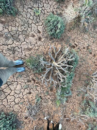 (Centrocercus urophasianus). The understory is where most plant species in the system live, making it rich in biodiversity and important to maintain. Preserving biodiversity can be a key to supporting the resilience of communities to climate change. This project will improve our understanding of how human and environmental factors (e.g., oil and gas development, roads, soil types, etc.) impact the radiation use efficiency of the understory plants. Radiation use efficiency is how much of the incoming solar radiation is converted to plant biomass. It has been used as a proxy for understanding stress and health of plants in agricultural systems but has never been applied to big sagebrush ecosystems.
Sam’s second project focuses on big sagebrush mortality events that have occurred when periods of extreme heat and drought are followed by an unusually wet period. With big sagebrush cover on a steady decline in the United States, an increase in the frequency of mortality events has the potential to increase the rate of disappearance of big sagebrush. This project will use field data combined with drone imagery of mortality events across the western US to produce a model that will identify and project the percent cover of dead big sagebrush across Landsat’s vast imagery library. Using Landsat’s over 30 years of high-resolution imagery, Sam will identify trends in location, size, and frequency of big sagebrush mortality events. The results will increase our understanding of how mortality events influence big sagebrush cover and will identify regions that may be most vulnerable to mortality events.